Some time ago I started working on some kind of data fusion problem where we have access to several imaging systems working in parallel, each one gathering a different multidimensional dataset with mixed spectral, temporal, and/or spatial resolutions. The idea is to perform 4D imaging at high spectral, temporal, and spatial resolutions using some single-pixel/multi-pixel detectors, where each detector is specialized on measuring one dimension in high detail while subsampling the others. Using ideas from regularization/compressive sensing, the goal is to merge all the information we acquire individually in a way that makes sense, and while doing so, achieve very high compression ratios.
Looking for similar approaches, I stumbled with a series of papers from people doing remote sensing that basically do the same thing. While the idea is fundamentally the same, their fusion model relies on a Bayesian approach, which is something I have never seen before, and seems quite interesting. They try to estimate a 4D object that maximizes the coherence between the data they acquire (the low-resolution 2D/3D projections) and their estimation. This is quite close to what we usually do in compressive sensing experiments on imaging, but with a minimization based on a sparsity prior.
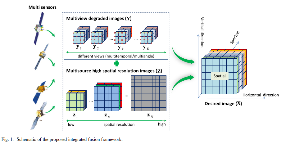
An Integrated Framework for the Spatio–Temporal–Spectral Fusion of Remote Sensing Images
By Huanfeng Shen ; Xiangchao Meng , and Liangpei Zhang, at IEEE Transactions on Geoscience and Remote Sensing
Abstract:
Remote sensing satellite sensors feature a tradeoff between the spatial, temporal, and spectral resolutions. In this paper, we propose an integrated framework for the spatio-temporal-spectral fusion of remote sensing images. There are two main advantages of the proposed integrated fusion framework: it can accomplish different kinds of fusion tasks, such as multiview spatial fusion, spatio-spectral fusion, and spatio-temporal fusion, based on a single unified model, and it can achieve the integrated fusion of multisource observations to obtain high spatio-temporal-spectral resolution images, without limitations on the number of remote sensing sensors. The proposed integrated fusion framework was comprehensively tested and verified in a variety of image fusion experiments. In the experiments, a number of different remote sensing satellites were utilized, including IKONOS, the Enhanced Thematic Mapper Plus (ETM+), the Moderate Resolution Imaging Spectroradiometer (MODIS), the Hyperspectral Digital Imagery Collection Experiment (HYDICE), and Systeme Pour l’ Observation de la Terre-5 (SPOT-5). The experimental results confirm the effectiveness of the proposed method.
As sensors evolve, the amount of information we can gather grows at an alarming rate: we have gone from just hundreds or thousands of pixels to millions in just a few decades. Also, now we gather hundreds of spectral channels at hundreds or thousands of frames per second. This implies that we usually suffer from bottlenecks in the acquisition and storage of multidimensional datasets. Using approaches like this, one can make it possible to obtain very good object estimations while measuring very little data in a fast way, which is always a must.
Bonus: Of course, they have also been doing the same but using Machine Learning ideas:
Spatial–Spectral Fusion by Combining Deep Learning and Variational Model
By Huanfeng Shen, Menghui Jiang, Jie Li, Qiangqiang Yuan, Yanchong Wei, and Liangpei Zhang, at IEEE Transactions on Geoscience and Remote Sensing
Deja una respuesta